Author Archive

Could Commuter Rail Equipment be Used for Affordable Intercity Travel?

Monday, February 25th, 2013
Commuter rail equipment waiting for the evening rush source

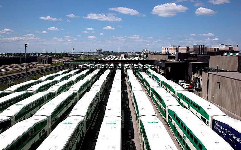
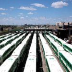
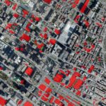
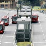
Toronto Commuter rail equipment waiting for the evening rush. source

The rail operator in France just started marketing a truly low cost high speed rail option. SNCF will soon start a new rail service under the name OuiGo (yes go! we go!), offering travel as cheap as 10 Euros for travels as far as 500 miles. This may be the cheapest HSR tickets anywhere in the world, and offer quite the competition to low cost air carriers or driving. Just like with the cheap airlines, users may have to deal with some inconveniences: passengers have to pay to bring more bags and to use electrical outlets, there are no cafe cars. And the travel doesn’t start in central Paris, but rather 20km east in Marne La Vallée, to avoid the higher track fees of downtown Paris. That’s similar to how low-cost air carriers offer travel from cheaper outlying airports. Unlike those airlines, though, SNCF is still offering uncompressed seating. 1,268 passengers can fit into the duplex-TGVs by ditching the cafe car and using an all economy layout.

This service got me thinking whether in North America we could have at least cheap medium speed rail options. Both VIA in the Quebec-Windsor corridor and Amtrak in the North-East Corridor offer reasonably fast service, but at prices and with service that appears to attempt competing with air travel. Both Amtrak and VIA neither have the capacity, nor speed to compete with low cost airlines. But they may be able to compete with cars and affordable bus travel offered by Chinatown buses or Megabus.

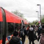
VIA and Amtrak may not have the equipment to offer afforable high-capacity service. But there’s plenty of rail equipment laying around most of the day that could be used for exactly that — commuter trains. The standard North American commmuter rail paradigm offers service mostly (if not only) during peak hours, dumping large numbers of trains in downtown yards, waiting to rush back to the ‘burbs during the late afternoon. I would prefer they would be used for all day frequent service, but there will always be unused trains during the off-peak. Could they be used to offer affordable intercity service instead of clogging up space downtown?

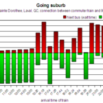
Let’s check the schedules of two commuter rail lines in Montreal to see when all the trains are really needed. The services use fewer trains than departures, because the earlier trains return back to the origin and do another run. For the Mont St Hilare line, the train arriving at 7:50 in downtown can’t make it back to the end of the line soon enough to be part of the morning rush – it becomes dead weight downtown. Only one train is needed for the midday service. For the evening rush, all trains are used starting with the 16:50 departure. For the Candiac line, there’s one train unused between 8:40 and 16:15. Overall, there are time slots of 7-8 hours during mid-day, and up to 6 hours after 6-7pm, when trains could be used for other duties.

Mont St Hilaire line (55 minutes per run):
arrive downtown: 06:30, 07:25, 07:50, 08:20, 08:50, 14:30, 19:25
depart downtown: 12:30, 15:50, 16:30, 16:50, 17:20, 18:00, 19:45

Candiac Line (40minutes per run):
arrive downtown: 06:40, 07:15, 07:40, 08:17, 08:40, 09:05, 09:30, 11:10, 14:00
depart downtown: 09:35, 12:20, 15:40, 15:55, 16:15, 16:45, 17:15, 17:55, 18:20

Commuter rolling stock may be a good match for high affordable high capacity intercity rail that doesn’t threaten the existing ‘premium’ rail market. It offers less space per passenger, but still much more than cars, buses or aircrafts. There’s also less space for baggage, meaning that it may have to be restricted in some way, just as for the OuiGo service in France. Commuter rail rolling stock offers a large amount of capacity, so even with cheap tickets the service may still be economically feasible. There are few amenities: no cafe cars (although one could install snack vending machines), no outlets (that’s a bummer for laptop carrying students), no wifi.

The cars tend to have lower maximum speed (100mph vs 125mph, or 80mph vs 100mph), so travel times may be slightly longer. This could be offset by having fewer stops, only at larger stations. Not stopping at small towns also matches trying to tap into large travel markets, and not competing too much with existing rail options for smaller markets. With fewer stops, fewer conductors are feasible because there is more time to check tickets between stops.

Travel between 9am and 5pm cut into regular work hours and is thus inconvenient for work-related travel. Travel after 6-7pm, i.e. twoards the end of the evening rush, with arrivals around midnight, may again be somewhat inconvenient for business traveless who may prefer taking intercity trains towards the beginning of the evening rush, in order to arrive during more reasonable times.

Schedule possibilities
A 7-8hour mid-day time slot allows for travel back and forth in the 2.5 to 3.5 hour range. Along the Quebec Windsor Corridor, this could match city paris like Montreal-Quebec, Montreal-Ottawa, Montreal-Kingston, Toronto-Kingston, Toronto-London. In the US, Philadelphia-New York, Philadelphia-DC and New York-Albany are easily doable, other city pairs will take longer than 4 hours.

In order to connect better city pairs that are more than 4 hours apart like New York-Dc, Montreal-Toronto, and Boston-New York, all of which have compatible commuter rail operations, one could send a train from each city to the other during the mid-day. The two trains could be used in the evening rush service at the destination city, for a sort of away game. The trains could then return either after the rush hour for a late night return, or during the next day. Equipment should be available during the whole weekend, allowing even more departures.

A note about non-main station departures: Gare Centrale in Montreal uses high-level platforms, which Toronto’s bilevel commuter cars can’t access. But the existing commuter rail stations of Vendome and Lucien L’Allier in Montreal are low platform, not far from downtown, and connected via the metro. In New York, there may be capacity issues going through the Hudson tunnels that connect Manhattan and New Jersey. If it’s impossible to add train departures even during mid-day, it may still be possible to have the trains depart from a New Jersey location that is accessible by rapid transit (i.e. Hoboken or Newark).

Montreal Frequent Service Map – Update

Thursday, February 14th, 2013

MontrealFrequentService150

This has been a long time coming, I’ve finally gotten around to update my Montreal Frequent Service Map. This is a map of the Montreal Metro and the whole 10-Minute Max Network. There haven’t been many changes:

  • The 211 Lakeshore is not a 10 minute bus any more. The STM chose instead to create a network of West Island express buses. Some of these follow approximately the route of the 211, so many of the stops along that route may actually see frequent service to Metro Lionel-Groulx every 10 minutes. But the routes are not exactly the same, and the mess of that all is against the spirit of a frequent service map.
  • The 132 Viau is now the 136 Viau.
  • The daily pass needed to use the 747 airport express now costs 9$.

I also took the opportunity to enlarge the West Island, and improve the proportions west of the Orange line, and added the missing LaSalle commuter rail station. I again made a 600 dpi version, which can be found here, and a pdf.

Everybody’s Talking about the Weather…

Friday, February 8th, 2013

With the snow storm hitting the North-East, and thousands of flights cancelled, I’m reminded of this ad from 1966. It’s for the Deutsche Bahn, the rail operator in (West) Germany at the time. It says “Everybody is talking about the Weather … not us”, and at the bottom, “just rather take the train, DB”.

Yes, the train does not rely on airports or cleared highways to run, and is at least in theory not disturbed by snow, low lying clowds, or vulcanic ash clouds. Often stranded due to weather, I have wished for a rail connection to where I wanted to go, not having to rely on airlines.

Of course this above ad seems optimistic nowadays, with the now semi-privatized ‘Die Bahn’ not being prepared for the winter as much as it used to, or when several Eurostar trains got stuck in the Channel Tunnel in 2009 due to “the wrong type of snow“. On the other hand, on that particular day, I was actually flying to Europe via London, had flights cancelled, and ended up stranded overnight on the Amsterdam airport – so I did not do much better than the people stuck in those trains.

514 Buses –
get Montreal bus schedules via cell phone

Tuesday, October 11th, 2011

Warning: I am currently transitioning this app to a new format so the schedules are not up to date (as of 2013). When I built the app, it relied on scraping the data from the STM's website, a painful process. I am now migrating to their GTFS feed, which will take some time.

If you are one of the two thirds of Canadian cell phone users who do not have a smart phone, you might find yourself late at night at a bus stop, waiting a very long time for the next bus home. If you had a smart phone with a Google maps app or the new STM app, you would probably have checked when the next bus comes, and waited longer inside that warm bar, or at the party where you were.

Sure, you could get the paper flyers of the relevant bus schedules, if you know where to get them, but it's still all very cumbersome. You could also use the phone service of the STM, telling you the next buses for one given stop. But it will only tell you the schedule if you know the 5-digit stop number and bus line - and you'll only find those once you are at the stop, so you still gotta wait there. And you won't find out about other nearby lines and stops.

So at last weekend's Back to School Hackathon, I thought it would be a good idea to try to make life a bit easier for those of us who still have that dumb phone, and developed a simple sms-based application that will tell you the next buses near a given address. You can just text your current address, intersection, postal code or point of interest to

514-600-1287 (that's 514-6001-BUS)***

and it will find nearby bus stops, and give the next scheduled departures.


Try the web-version:
address:


As you can see, the app returns a very compact result**:

  • At the top it shows the time relative to which the schedule is displayed
  • It will show a compact name for each bus stop, with the distance (in metres) from your supplied address
  • for each bus stop, it will show the buses, together with their direction (W,E,S,N), and the next couple of buses, in minutes relative to the displayed time

The app properly deals with weekend days, holidays, night buses. It will also deal with special characters that show up in the original schedule (">" or "+"). They will be displayed, and usually mean that the bus is taking some alternate route. The system knows 96% of the bus stops (although some might be located incorrectly). and supports the following options:

  • the first word can be set of option characters. W, E, S, N will display only buses in the supplied direction, H will display wheelchair accessible buses using '*'. Multiple characters can be used in one word. Example: "WEH 688 Sherbrooke" will show all westbound and eastbound buses, and show handicapped access.
  • You can add a trailling "in number", where the number is in minutes. This will provide the schedules relative to a time in the future. Example: "h3a 2t5 in 30" will show buses near postal code H3A 2T5 in 30 minutes.

This application, given the 160 character limitation, naturally does no actual routing. It just gives scheduled departures. You still have to know your lines. This fits the idea that many people do know the routes of buses that are relevant to them, even if their don't know the schedules. This complements the idea of the frequent service network - you know how to get there, but you would like some independence regarding schedules. By making this an sms app rather than a smart phone app, I hope for this to be useful to more people.

Some argue that smartphones are not a game changer for transit. But tools like this should help reduce some of the stress associated with taking buses - the wait at the stop - and maybe will make some travelling a bit more enjoayble.


disclaimer: This is currently beta. The phone number may change. The phone system may not respond at times (in which case try resending your request).

**Update: Due to a recent outage at tropo, the sms service, I changed the system to respond via another service, twilio. So the system will now respond with a different number (which should also accept requests - but it is a US number). Along with this change the format of the response changed to show absolute times rather than relative times.
***Update: After the service called twilio started offering canadian phone numbers with sms support, I have switched over the service to this new number. The old number ((514) 418-0428), should still work for a while.
****Update: As per the warning above, the schedules are out of date.

The STM and the illusion of participation

Friday, December 3rd, 2010

The STM, Montreal's public transportation agency, presents itself as fresh and new and user-oriented, with a recently revamped corporate design (which is admittedly pretty nifty) and a public campaign involving tv spots and a new blog. They try to project an image of user focus.

Just now the STM offered a new set of exciting choices to its users: the color scheme of the new metro cars. The choices are: blue and white, white and blue, and... blue and white. Really...

If the only choice they allow Montrealers to make is the color of the cars, why not at least have an open competition allowing the submission of actual designs - rather than this top-down approach?

This is not the first time the agency has invited Montrealers to vote: back in March, users could choose a new seating configuration in the metro cars (which needed more standing room for the rush hour crush). This was a two-step process with somewhat narrow choices. The STM probably should have gotten somebody to explain that maybe putting benches all along the sides is the best compromise to keep the most seats while providing much more standing space, even if it doesn't look like it on paper and gets rid of those precious individual seats.

Back then the vote seemed like a ruse, an attempt to conceal the fact that the metro was at capacity, and the new contract still in the courts.

Now, the bitter aftertaste is the price of the cars - up to a billion dollars more to replace the whole fleet, because nobody seemed to have a problem with foregoing the open bidding process and awarding the contract directly to a Bombardier-Alstom cartell, despite a cheaper offer from a foreign builder. Nobody, except some opposition in the city council, and of course many users - but they don't have much say.

We don't get all that much say, whether it is about awarding an expensive contract to put GPS units into buses and build a new communication center (the suburb of Laval paid much less), or about selling station and metro line names to the highest bidder (particularly ironic: the color scheme of the metros car is part of our identity and heritage, but the system itself apparently is not).

I also don't remember any public hearings regarding their recent fare hike, either. They simply get announced. Unlike in New York, where the recent fare hike was part of a long and angsty debate (the conclusion of which was to make the unlimited ride card more expensive, rather than cap it).

There was a debate this summer about putting air conditioning into buses and new metro cars, but right away the STM decided top-down that it would cost too much money. It was not deemed a priority, and the funds would be better spent on service improvements.

Yet just recently, the agency introduced new sharp, but dysfunctional bus shelters, that are slated to replace existing ones. The new ones have exactly the same geometry; they are simply more expensive. Admittedly, the STM did ask their users for their opinion. But just like when asking us our opinion regarding the "bus of the future" line 467 upgrades (which are actually pretty nifty), our participation is more like a foot note. A survey that feels a bit as if it is mostly in place to reaffirm the usefulness of the investment.

My problem is not that their service is bad, or that the organization is going in the wrong direction. In fact most of the initiatives are good - the frequent service network, the 'bus service of the future', the new corporate design. And I don't disagree that the metro cars should follow the heritage colors, and are part of the Montreal's identity. And that most of the times, transport planners probably make better choices than the crowds.

I simply don't like how they interact with their users. Why pretend that the users have some sort of say? And why take already decided issues (e.g. the removal of seats from the metro), and let people ratify them via mundane votes that attempt to hide the underlying decision?

Participation should not be a marketing-tool, but a way for a public institution to be accountable to the public. And trying to give people a sense that they are being listened to should not come through a giant campaign to illicit votes on mundane choices, but, well, listening.

Trying to talk to them can be a bit difficult. On car-free day earlier this year, where some local transportation agencies each had a stand, I spoke to STM representatives (some hired PR people, really) and tried to point out a small mistake on their 10-minute max map. They weren't really interested. I also emailed the STM. They didn't respond, and the mistake is still there online. In fact they never answered any of my emails.

At the same event I had a lengthy discuission with a representative from the RTL (the transit agency of the South Shore suburbs) about the merits of fixed interval schedules and timed transfers; leaving a much more positive impression without all the spark.

The silly thing is that Montrealers will choose the traditional color scheme.

Bike Contrails

Thursday, December 2nd, 2010

Contrails is a project to turn bicycles into a paint brush. The goal is to create a device that attaches to a bike and leaves a washable chalk like trail - a bike contrail.

The Brooklyn, New York based organization behind the idea recently completed a successful kickstarter, raising ten thousand dollars. This will allow them to mass produce 2000 devices for relatively cheap, giving half of them away to non-profits.

You may call it public collective art, or just a nuisance. I think it's a pretty neat idea. Like ants marking their paths with pheromones, it will show where bicyclists go. I am not sure whether it can help increase safety per se, as the group claims, but it will surely increase the visibility of bicycling. Which could help to make people more aware of this mode of transportation and encourage more cycling. Plus, it looks like a fun toy to use.

images and video via bike contrail

Construction of the Train de l’Est begins
– at 87,000$ per commuter

Thursday, October 21st, 2010

Last week the AMT started the construction of the first stations of the Train de l'Est, a new commuter rail line linking the downtown of Montreal with Montreal-Nord, the east of the Island, as well as Repentigny and Mascouche off the island. The line goes through the electrified Mont-Royal Tunnel, then along a single-tracked CN right of way until the East of the island, then 12km on a new track in the median of the 640 highway to Mascouche. The first trains are projected to roll in September 2012, probably as far as Pointe-Aux-Trembles or Repentigny. It's the revival of a shorter all-electrified line, which ceased operation in 1968.

Train de l'Est as projected by the AMT

This is a project that the suburbs have been lobbying for for years. And this is the main problem with this project -- it is very much oriented just for them. 478 million dollars are spent to move a projected 5500 suburbanites downtown and back - 11000 trips on a weekday on a 53km-long line along a track that mostly exists today. That's 87,000$ dollars a person - one could buy cars for all passengers at a fraction of the cost. It's more expensive per rider than the ridiculous 16$ Billion Second Avenue Subway in New York (probably the most expensive transit project ever). Also In comparison, the extension of Montréal's Orange line into Laval at 745 million dollars brought in 30 thousand new weekeday commuters. That's 25,000$ per person to blast a completely new subway tunnel under a river, not to add a couple of stations to a mostly existing track.

The issue is not that the project is too expensive, although it should probably be cheaper - it was originally projected at 300 million. The problem is that it's not designed to get a enough riders, especially on the island. It's not an effective use of resources, both financial and infrastructure (e.g. rail right of ways).

It's not that there is no demand. The line passes through the North of Montreal, through the boroughs of Montreal-Nord, Ahuntsic Cartierville, Villeray-Saint-Michel-Parc Extension and Saint-Leonard, which have a total population of 420,000. It intersects and runs parallel to some of Montreal's most frequented bus lines.

  • the 139 (Pie-IX) with 40,000 daily trips,
  • the 67 (St-Michel) with 40,000 (in 2008),
  • the 121 (Sauvé) with 38,000, and
  • the 69 (Gouin) with 27,000.

All these bus lines feed people into the distant metro system to get them downtown. The four lines alone see more than ten times the traffic the train is supposed to get. Earlier this year, Spacing Montreal published an article entitled Montréal-Nord in exile: Public transit and social exclusion, which explores the connection between the troubled areas in the North of Montreal and its public transit woes, and the hope for the new train.

But right now I find it doubtful that many riders will be able to benefit from this train. Sure, it will be faster, but there are very few stations in Montreal Nord - only 2 along a 6.5km stretch (Montreal-North at Pie-IX, Saint-Leonard at Lacordaire), so people have to travel farther to reach a train stop. The trains will only have 5 or 6 departures during rush hour, whereas the buses come at least every 10 minutes. This means you have to plan your daily schedule completely around the train. But you still have to pay a higher fare - almost 50% more for the monthly pass, up to twice regular fare for students. And by the time the trains pass through Montreal-Nord, they are going to be packed, making the trip basically as unpleasant as the bus ride.

The AMT plans to build an "intermodal hub" at Anjou, but are at the same time putting 4223 parking spots along the line, with a provision to add 1322 more - so every projected rider is to arrive by car (I've written about the commuter rail's misguided focus on Park and Ride facilities, they are not "intermodal hubs"). So the focus is not on urban dwellers, many of whom do not own a car, but rather on suburbanites.

And thus the train becomes an extension of the car into downtown, rather than the extension of transit out; it encourages sprawl and perpetuates car-dependent life styles.

But how could the project be expanded to improve service in Monreal?

A possible way to expand this project to improve service to the north of Montreal would be to construct a surface metro, similar to the plan the city already had back in 1981, putting several stations along the badly served, heavily populated, bus-riding neighborhoods around Montreal-Nord.

New, dedicated, electrified double-tracks could be installed up to Papineau, then single tracks to Anjou. With a passing point around Viau, this would allow service as often as every 10 minutes to Anjou. Such a schedule could be accomplished with only 6 or 7 trains, all just running back and forth, totaling around 200 departures a day. If only one single track where built, one could serve Papineau every 20 minutes, or Saint-Leonard (Lacordaire) every 30 minutes, both using only 2 trains.

200 departures a day with 7 trains

Currently the AMT plans to provide 16 departures with 5 trains. In the morning, all trains start at Mascouche and get dumped into Gare Centrale. Only few run back and forth more than once. You need a lot of trains for fairly little service, and you need a lot of space downtown to store those trains during the day. But on the current CN-owned non-electrified freight track you cannot easily provide more service. On one hand, running on diesel is much more expensive than running on electricity; the AMT could not afford to send back nearly empty trains. On the other hand, CN would not allow that much passenger traffic on their freight line.

Note how despite the many extra stations, the travel time could actually be similar to the currently projected ones: electrified trains accelerate much faster than Diesel trains. The new dual mode trains that the AMT will use are almost twice as powerful in electric mode. Modern light-weight electric multiple unit trains like Alstom's Coradia Nordic (built for Sweden's Commuter Trains), Siemens Desiro, or Stadler's FLIRT etc. etc. are even quicker and could easily make the above schedule given good track conditions, and decrease travel time from Montreal-Nord up to 50%. Having many existing train manufacturers also means that they are more affordable due to the competition (unlike the rubber-tyred metro). maybe 10 to 20 million dollars for a whole train carrying a thousand people.

Coradia Nordic operates down to -35°C, goes up to 160Km/h (wiki-cc Udo Schröter)

Now the AMT will tell you (and has told me in the past), that this is not their market; that travel within the city should be done by bus or by metro. But given the expense and slowness of metro expansion, and the need to provide more transit in the area, the AMT should really get into the rapid transit game inside the city. The 10 minute service as shown above, together with the diesel operation to Mascouche could easily carry 80,000 trips a day, maybe more, at a cost of 200 to 400 million dollars extra, including rolling stock, if the design is kept lean and functional.

The CEO of the AMT, Joël Gauthier, believes, and he is probably correct, that there will be much more demand than 11000 trips a day. The idea is to put the train into place with 16 departures a day, and expand it if there is more demand - in negotiation with CN. This sounds a bit like "let's create a crappy service, and if it's successful, we'll try to make it better maybe." Lets hope that at least the current stations are built so that more tracks can easily be added, and maybe one day the surface metro can become a reality.

Breakthrough of the Longest Tunnel in the World

Friday, October 15th, 2010

The longest tunnel in the world is now in Switzerland. Since 8:00 Eastern Time this morning, when a TBM broke through the walls to form the Gotthard Base Tunnel. This 57Km train tunnel, to be completed around 2017, at a cost to the tune of 1300$ for every person in Switzerland, represents this country's vision of a future on rails; to get the freight away from the congested roads of the Alps; to cut down travel times between Switzerland and Italy by about an hour with trains traveling at 250Km/h through the underground passageway; to connect Northern and Southern Europe divided by the massive mountains. And In North America we watch with envy.

Car-Shaped Bike Rack Design

Tuesday, October 12th, 2010
This is too clever not to share. It's a concept for a bicycle rack, an entry to Designboom’s IIDA Competition. It shows bicycles reclaiming the space taken by cars. Also illustrates nicely how much parking space a car takes compared to a bike. via inhabitat

Bike Share Maps Around the World

Tuesday, October 12th, 2010

Bicycle sharing has been spreading across the world. Velib in Paris, Bixi in Montreal, most recently Capital bike share in Washington DC, etc. etc. The newest generation of bike sharing can provide more mobility than any other form of transit for short distances in dense urban areas. You can hop on at a station, and drop off the bike at another. You don't have to worry about getting your bike stolen, or where to park your car. You can get to some place by bike but than continue walking or taking public transit. Which is not true for cars or bikes - you always have to come back and pick it up.

For many trips within downtown areas, it's simply the fastest way to get around, if you're willing to lug around these somewhat heavy bicycles. Although the metro has much higher average speeds, the long winded walks down to the station and waiting times mean that you can be faster on a bike operating at street level. There's also less stress due to waiting, because the bikes are waiting for you at the station ... well, in theory.

The biggest problem with modern bike sharing systems is that stations can be full, and they can be empty. If there is no bike at a station, you can walk to the next one and hope to find one there. This means you cannot rely on this form of transport, especially in mono-functional job centers, as the Yonah Freemark at the TransportPolitic argues. He also finds that a bike share system needs a high density of stations, which might be a problem for Washington's bike share:

The systems seem to be targeting shorter trips where walking is possible as a backup. This might be one of the reasons why bike sharing tends to replace walking and transit trips rather than car trips. A survey in Montreal found that less than 10% of trips on Montreal's Bixi would've been done by car.

Uncertainty is a big problem - it means stress. It is stressful to take a bus that often comes late if it all; just like it is stressful to drive downtown when the parking situation is uncertain. Stress makes a form of transport less appealing and less competitive compared to others. Wandering through downtown after 5pm searching for a bike is not just annoying, it compromises the whole idea of the easy-hop-on-hop-off bike share system.

This is where real time maps come in. They can bring back some of appeal to the system by giving back the certainty where the bikes are. You still have to walk longer to get to your bike, but at least you know that there is one, and that you find the closest one to where you are.

Olivier at Suprageography made some really neat maps. Originally just for London, Now for fifteen cities around the world:

The maps include fancy features like showing an animation of the distribution of bikes during the last 24 hours (only for really fast computers), and showing the distribution of bikes at a given station during the last 24 hours. While these are neat visualizations, it's doubtful whether they are going to be very useful to users seeking to improve their biking experience. What would be nice to see is some improvement in performance so that more mobile and netbook users can benefit. Given that there has been continual development, this is probably not so far off.

Transit ridership Higher in Canada than in US, Australia

Friday, October 8th, 2010
Canadian cities get consistently higher transit ridership ratios than cities in the US or Australia, according to a recent article at Human Transit.

image via HumanTransit.com

The graph shows the percentage of people commuting to work by public transit, compared to the population of the cities. The transit share tends to be higher for larger populations -- but at the same time there is the trend that Canadian cities see a higher transit mode share. This anomaly might be due to the great weather, better concentration of employment centers, higher apartment renting levels, or a perception that people take the bus to be progressive rather than because they are poor. Either way, this is how Jarret puts it:
In any case, we're on the leadup to Canadian Thanksgiving, so I thought this little occasion for Canadian triumphalism would be apt.

Montreal metro cars: Bombardier wins contract, Taxpayers loose

Wednesday, October 6th, 2010

Berri Metro station - The system is at full capacity now, new cars would really be nice - cc flickr abdallahh

Now it's official. Instead of trying to get the new Montreal metro cars at market value, Quebec just confirmed that the contract is directly going to be given to Bombardier. Without a bidding process. This comes just a few days after the government asked the STM to delay the opening of the bidding process, so that the province can pass a law that would allow the STM to directly negotiate with Bombardier/Alstom based on their 2008 bid.

The Montreal blog fagstein offers this timeline:

He also offers a projection on what will happen next, which can be found in his article here.

It already is very fishy how Alstom first sued to get an open bidding process on the cars -- the whole point of which is to get a market value deal for the taxpayer -- but then suddenly joined with Bombardier just to undermine that exact same process.

It is also strange that the call for bids at that time had restrictions that would only allow Alstom and Bombardier to bid. It required that any bidding company had rubber tyre metro technology running somewhere for at least 5 years. This made the whole bidding process moot. That's why Spanish CAF sued to begin with, to get a chance to bid as well.

Now CAF, desperate to get the contract, just offered to build the metro cars for only 1.4$ million dollars - almost the same amount that they got paid by the Santiage metro System to build basically the same metro cars. In comparison, Bombardier/Alstom is currently asking for 2.6$ million. This is down from originally asking 3.3$ million; just the threat of an open bidding process lowered the price.

But That's still 1.22$ billion vs caf's 670$ million offer for the whole order - 550$ million less. And this being a continuation of the 2008 bid, before the order get expanded to the whole fleet, the difference would grow as the STM would exercise the option to order more cars at the same prize. The difference could grow to over 1$ billion dollars.

Now why would the government push this through if it represents such a huge burden on the tax payer?

Cars = Too old?

The claim the Charest government makes is that the metro car issue is becoming urgent, that they cars not to replaced soon. And sure, the oldest cars are from 1963, almost 50 years old. But just this summer the STM confirmed that the metro cars are old but safe.

The maintenance costs will grow in the next couple of years, but it seems hard that they will grow to hundreds of millions of dollars. At the same time I wonder how many months the bidding process will delay the delivery of the cars. My guess is that the final negotiations, engineering and testing will overshadow the bidding time, anyway.

CAF = Unreliable?

The claim on the side of Bombardier/Alstom is that their technology is much more reliable, that caf simply doesn't have the expertize. "There's no way that (Montrealers) should be the STM's guinea pigs, with all the risks that it entails, including the maintenance of these cars for the next 40 years", they claim.

But CAF is building rubber tyred metro cars for Santiago, and they also hired former Bombardier employees. Surely that should give them at least some credibility.

Another claim is that caf won't build most of the cars in Quebec. Yet, a requirement of bidding is that 60% of the work has to be done in Quebec either way. In any case this is a requirement that should be tested by the open bidding process, and not by claims of the competitor, or the gut feeling of some politicians.

Bombardier = good for Quebec?

Quebecers have positive feelings towards Bombardier. The company was found in Quebec, started as a small shop in the Eastern Townships. It built the first metro cars. It creates jobs. Quebecers have dear feelings towards the company, they are one of 'us'.

But in the end of the day Bombardier is just a company, a multi-national one, that answers to its stock holders and not the people of Quebec. It is not a guarantor of jobs in Quebec. This summer the company just showed that when it cut back on jobs in the plant where it intended to build the metro cars, and threatened to shut it down of they wouldn't get the contract.

At the same time Bombardiers is building rolling stock all over the world. Bombardier doesn't really care about Quebec, maybe then they would offer the taxpayers a better deal. At the same time, given that caf would have to assemble the metro cars in Quebec, the Spanish bidder would have to open a plant here as well, anyway. So the contract will create jobs in this province, no matter who is getting it.

Contract with Bombardier = Votes?

There is another angle to the story. The decision to fast-track the metro contract might be due to electoral goals. The riding of Kamarouska-Temiscouata, where the Bombardier plant is located, is about to have a by-election to replace national assembly member Claude Bechard, who passed away on September 8th. Surely saving a thousand jobs in that region will gain the Liberals some support, and they might win the seat.

If that is actually the case as some suggest, then this will be a very expensive way of buying the seat. As an article in 'argent' puts it: $ 1 million per vote.

Whatever the actual reason is for this maneuver, something is seriously wrong here. This whole bungled deal, despite going on for years, has not resulted in the best possible deal. CAF is not amused, and even the Spanish Ambassador is getting involved.

It is ironic that this comes just as Quebec is outraged over a trolling MacLean's article proclaiming Quebec to be "the most corrupt province". Even the Quebec government demanding an apology. Now the same government is mysteriously giving Bombardier an over-expensive contract. And the taxpayers are going to have to pay.

Is Montréal paying too much for BRT on Pie-IX?

Friday, October 1st, 2010

According to a recent gazette article, the cost to build 15km of bus rapid transit along Pie-IX is projected to cost 305M$. This includes154M$ for 10km in Montreal, 125$M for 5km in Laval, and 26$M for unforseen expenses. The higher relative cost in Laval is due to having to modify on/off ramps, and building parking lots.

Now Yonah Freemark at the Transport Politic asks whether Montreal might be paying too much. He compares that to Besançon, a small city which prides itself building the cheapest TRAM system in France:

It’s a question Americans should be asking themselves, since the costs of transit investments seem to be spiraling out of control even as the demand for alternative transportation options has increased and the funds to support them have diminished. Besançon, a city of about 115,000 in a region of about twice that size, has managed to develop a project whose costs are acceptable — “optimized,” the local transit agency calls them — even in a small metropolitan area.

Besançon will be getting a light rail line fully in its own right-of-way that extends over nine miles and thirty stations, all for a price of €228 million ($310 million), with construction beginning this fall. The city expects about 43,000 daily riders once the project opens in 2015. This is no streetcar, and yet plenty of U.S. cities are thinking about spending far more per mile on those limited ridership, low-performance systems.

He goes into a further analysis on how they cut costs, by avoiding surface construction as much as possible (i.e. ban cars instead of rebuilding streets) keeping station design simple, and getting the best prize on their rolling stock. Apparently the city negotiated with six candidates to produce the rolling stock, fostering competition. It then awarded the contract to CAF (the Spanish company that would like to build the Montreal metro cars..), and now pay 30% less than Houston for similar technology from the same company. The lower cost is partly due to not requiring much customization.

The example might not be very comparable to Montréal, and what the city hopes to achieve on Pie-IX. And one could argue that if you buy cheap you get cheap. But in the end of the day, the desire to keep costs low on transportation projects is a virtue that seems to be lacking in Quebec, and the rest of North America. And it means that tax payers will pay more to get less, and will have to wait.

Better Buses II: Building the Network

Friday, October 1st, 2010
This is part II of a series on ideas how to make frequent bus services more attractive, see part I The way the STM in Montréal built their frequent network is to label some already heavily used lines, and add some service during off peak hours here and there to get an all day 10 minute frequency. As far as I can see none of the lines were altered. Given that these routes evolved over time, according to ridership, alongside dozen of other lines that are not part of the frequent service now, it's a bit surprising that the result actually does make for a decent network. It covers a large area of the city reasonably well and provides a good number of connections with itself and the metro. In some other cities where users tried to map the their frequent bus service, the result is sometimes erratic, with routes concentrated in few corridors or only certain parts of the city. In Montreal the network almost looks as if the routes were specifically designed to form a network of their own. Almost, that is. There are some areas where the network could use some improvement. After all, the system did evolve with coverage in mind, rather than frequency. That means that on many corridors multiple lines overlap, so the individual lines provide less service. Building a frequent network thus requires some adjustments. closing the gaps A number of the bus lines terminates shortly before reaching other lines in the frequent service network. These gaps should be closed. A transit system is supposed to be a network, not just a set of corridors. More connections mean more choices in how you plan your trip, which means that users might be able to plan a shorter or faster trip. The possible advantages should really outweigh the resources required to extend a bus line a few hundred meters. At the end of the lines, transit lines tend to run empty, which does not represent an efficient use of resources. This is because the only people on the bus will be the riders who have these stops as their destination. If passengers can connect to another service at the end of the line, there are more passengers who could use this segment. Also, if the terminal station is a metro stop, there is some incentive to travel against the downtown flow. For example, if the 24 in the image above would connect to the Joliette metro station, the last couple of stops could act as a feeder to the metro, even for passengers going downtown - the metro is simply much faster than the bus. consolidated lines are frequent lines From the frequent service map it becomes quite obvious that although the East of Montreal has a fair number of frequent lines covering a large area, the West Island only has 2 lines -- and those only go downtown every 10 minutes from 9h to 14h, and in the other direction thereafter.

The West Island of Montreal

One might remark that the West Island is generally more suburban -- car ownership levels are higher, and the density is lower. But there does exist some bus service. And along some corridors buses are fairly frequent.

Excerpt of West Island bus service - many overlapping lines almost form frequent services

But it seems to have evolved with the desire to create coverage and one-seat rides, rather than frequency and working network. On some corridors (for example on sections of St Jean, Saint Charles, Pierrefonds, Lakeshore, Des Sources) there are multiple overlapping lines, that converge, and diverge after traveling together. Together they almost provide frequent service already -- or at least several buses an hour. Some overlapping lines are scheduled so that there are a couple of buses in short succession, and then none for 20 to 25 minutes. There is potential to consolidate these lines and provide more lines on the map, without having to spend too many extra resources. An easy and frequent grid (like in the East of Montreal) could also attract more riders, who currently use their car; according to the motto "if you build it, they will come". There is a similar potential in the North East of Montreal, where several of the half-frequent lines overlap. It seems that consolidating lines could yield all-day frequent service lines. more connections As mentioned before, closing gaps can improve the network and could mean fewer transfers or faster travel for some people. Some gaps, that do not really look holes in the network, because there are lines - they are just not connected in a very convenient way. One example is the 105 bus: Many riders would actually like to connect to the green metro line, and are thus forced to transfer to the orange line, and then the green line. Because the metro takes a detour, and extra transfers are needed, this can be quite an inconvenience. Commenter Zoltán puts it like this:
Yet they still can't quite bear to create a frequent Sherbrooke line, one of the most obvious possibilities of a simple Montreal bus network, by merging the 24 and 105, with a short diversion (about 500m) to serve Vendôme. As for points on Décarie, the resources used to provide the frequent 24 could either provide a frequent shuttle from Vendôme to Villa Maria Metro, or more usefully could enhance frequency on the 17 running all the way via Décarie, with the 102 running all the way via Girouard.
Merging the 24 and the 105 is one possibility. It would create a pretty long line with somewhat uneven load along it, which might cause bunching one the one end and emptier buses on the other. One could also just run the 105 to the Atwater or Lionel-Groulx Metro station. Either way, the goal should be to create a more complete network.

AMT Announces Rebuilding of Intermodal Station on the South-Shore, Leaves Open Which Modes These Are

Monday, September 27th, 2010

More AMT news, Montreal commuter trains are on a roll. On Friday the agency announced that 19.7 $ Million, compared to the originally budgeted 6.8$ Million, will be spent to rebuild Gare Saint-Hubert into a more permanent commuter rail station. 75% will be paid by the Ministry of Transport of Quebec, the rest by the AMT. The station with rebuilt platforms will include 335 parking spots (on top of the existing 280), a tunnel to connect both platforms, a new ticket vending machine and shelters for rail users. Bids will start in winter 2011, and the construction is scheduled for summer 2011.

Nowadays when I hear inter-modal station, I think trains and cars. It is good that drivers are encouraged to leave their car in the 'burb, rather than congest them into downtown. But it seems to me that this focus on park-and-ride facilities ignores the fact that the RTL, which serves the greater Longueuil area, provides some of the best bus service a suburb in North America can provide.

It is ironic that the cost increase seems mostly for the benefit of car users. The parking lots apparently add a lot of cost. Yet, it takes up valuable real estate around a train station that is only going to see service increases in the coming years - an ideal place for transit-oriented development. I've written about the hidden problems with parking before, but it should be fairly obvious that here, it will force developments away, not promote a transit-dependent life style, and encourage sprawl. At the same time, there are some that claim that the ability for park-and-ride to attract transit users is a myth.

Every parking space represents only one extra rider (maybe 1.3) on the trains. Yet despite not being an 'intermodal hub', the station is already served by three bus lines (8,28,88), which together have about 150 departures on a week day in each direction. If ones assumes 10 riders per bus (a very low estimate), it means that about 1500 people can reach the station already - more than twice the capacity of the planned parking lots. And this number could easily be increased when the buses are scheduled around the train station to be a hub - at a fraction of the space(=cost) used by cars.

The strange thing is that according to Longueuil mayor Caroline St-Hilaire, transit oriented development is exactly what they had in mind:

This new economic development center will have a higher density and mixed use, as well as more friendly facilities for mass transit and non-motorized methods of transportation
From the planned picture above, and given how much parking space will be added, it is hard to see how these goals will be met.

Now, we can argue back and forth about the problems and merits of park-and-ride facilities vs transit-oriented development, but it should be clear that the intermodal station should be designed first and foremost with the connection between the bus and the train in mind. One way would be to create intermodal platforms, like this

Intermodal Station Altenkirchen (Pop. 6700), Germany. The rail line is single tracked, so all trains stop there.

Or like this

Metro Station Mortensrud, Oslo

Conceivable would be a station with two intermodal platforms - in the morning all buses could stop at the platform with the trains going downtown. In the afternoon they could stop at the outgoing platform. Whoever is going against the flow has to go through the tunnel.

If the station is reasonably sheltered, transit riders could switch from bus to train without much effort, and without rain or snow. Now that could provide a ride comfortable enough to persuade drivers to leave their car at home, while rewarding those who do that already.

images sources: AMT handout via Montreal Gazette (thanks to Andy Riga), Altenkirchen, Oslo, own work

Bombardier Unveils Dual Mode Locomotive to be Used by AMT and NJT

Thursday, September 23rd, 2010
Bombardier yesterday unveiled (also here) its new dual mode locomotive at Innotrans 2010 in Berlin. It is to be used on the new Train de l'Est commuter line in Montreal, and some lines of the New Jersey Transit (NJT). They trains are purchased in a joint bid by AMT and NJT. The AMT has ordered 20 of these 130-ton machines for 236.3 $M, of which 75% is paid by the ministry of Transports of Quebec, and 25% by the AMT. This is interesting because this new train could significantly improve the AMT network. The Mount Royal Tunnel going under the mountain does not have enough ventilation to support trains running on diesel engines; only locomotives powered by electricity are allowed through. This means that the only trains that can currently go through the tunnel are the ones of the fully electrified Deux Montagnes Line. But none of the other AMT lines are electrified at all, so the electric trains cannot serve those. The Dual Mode train, which can switch between electric and Diesel operation, can go through the Mount Royal Tunnel, but at the same operate on any other line. This opens the possibility to finally route the Blainville-St-Jérôme Line directly downtown, and makes the operation of the Train de l'Est, which is now planned to open in 2012, only possible. Additionally this would allow routing lines through downtown, for example all the way from Mont-Saint-Hilaire to St-Jérôme. But also this opens up the possibility for gradual electrification of the whole commuter rail system. Electrification means cheaper operation of trains. It means the possibility to have rolling stock that accelerates and decelerates faster (because of less weight); giving the possibility for higher frequency and more downtown stations (surface metro, anyone?). The AMT is studying the possibility to electrify the whole system. Let's just hope that Jöel Gauthier, CEO of AMT, got a chance to ride the S-Bahn in Berlin, to see where the AMT could be in 20 to 30 years.

Every Day Should Be Car-Free Day

Thursday, September 23rd, 2010
Rue Ste-Catherine in Montreal has been full of people at every occasion they are allowed on the street, including the current car-free week. Since it is a really bad street for cars, would it be a good idea to turn it into a pedestrian mall all the way? As part of "In Town Without My Car All Week Long!", held from September 20 to 24, a portion of Montreal's downtown around Rue Ste-Catherine was open for pedestrian traffic yesterday. Ironic that the official map calls the areas "closed"; I'd probably call them "open": Despite being part of a "week" without cars with activities surrounding car free living, the cars were apparently only banned for one day. Which is unfortunate; people seemed to like it. The street really came alive, and the make shift park added a lot of atmosphere; it was kind of Zen. There has been some talk about pedestrian malls in the blogosphere lately. On the one hand, New York has been expanding it's pedestrian zones, starting with Times Square last year, and adding newest stretch just yesterday. On the other there are voices saying that pedestrian malls might be hurtful, that some cities actually revived their downtown by bringing back cars, and that pedestrian malls don't work in North America (compared to Europe or even Australia).

Ste-Catherine during a normal work day - 1 car per 20 pedestrians

The main problem seems to be that a typical downtown of a North American City is a mono-functional office-space-oriented place, which is only alive from 9am to 5pm. After that, everybody goes home. And if you cannot take your car back to downtown, people apparently rather stay back in the suburb. If nobody lives downtown, there shouldn't be a reason for anybody to be downtown, right? And without people and without cars in the streets, people will start feeling unsafe and continue to avoid the area.

The Gay Village was closed to traffic from May 26 to September 13

But on Ste-Catherine, complete pedestrianization might actually work. Not many people live along the street. Not only does it run through the downtown office center, it also has a vibrant night life, from the Gay Village on one end, to the 2nd Chinatown/Concordia Ghetto on the other.

Some street festival/concert in the Concordia Ghetto

The street is always full of people, many more than there are cars. In fact, as a car user, you should really know not to drive on Ste-Catherine, because it is essentially useless as a car artery. Traffic flows really slowly due to too many traffic lights, and is interrupted half way by all sorts of festivals, pedestrianized areas, or road closures because of construction.

If not the pedestrians, some construction will surely block the path, anyway

At this point, hasn't the street shown its viability has a people-only space? Haven't drivers given up on this street at this point, anyway? Can't we finally ban the cars for good, and maybe add a bike lane? Don't we want every day to be car-free day on Ste-Catherine?

Better Buses I: Frequent Service Does Not a Network Make

Tuesday, September 21st, 2010
This is part I of a series on ideas how to make bus services more attractive

While making a map for Montreal's frequent bus service, branded the "10 minute network", it became obvious that just taking a couple of heavily utilized bus lines and upgrading or labeling already existing all-day frequent service doesn't make a network yet. The STM should now focus on creating creating a new level of service. Before this brand there were two levels of transit within the island of Montreal: A primary, The metro, with high speed, high frequency and good reliability in a network that can be easily understood; and a secondary, a large list of bus lines, with all sorts of different service patterns and some with very low frequency (I am not counting the commuter trains at this point, since they don't seem to be designed for people on the island of Montreal).

Many users will likely rely on the metro as much as possible and only switch to buses where the metro is not available -- or when taking a trip every day. Commuters tend to find the services that is most useful to them, even if it is obscure, infrequent and relies on expert knowledge. The metro on the other hand will get you to many places and the only thing you need to know when you start your journey is the station where you want to get off; no schedules or further geographical knowledge is needed.

The reseau 10 minute max attempts to create a new secondary network, supplementing the metro, which can also be easily understood and which is frequent so that no schedules are needed (we'll see about the reliability come next winter). It is most useful if it emulates the user experience of the metro as much as possible, while creating a network that makes sense by itself, covering most of the city in tandem with the metro. It should be accessible and appealing to the novice user, who can then reach any part of the city without much preparation etc. This should improve mobility, and thus the ability to rely on public transportation, making it more competitive form of transport.

This idea is partly due to Jarret Walker at provide a similar experience as rail, that they are equal in a way. I believe that rail is the better form of transit in many instances, but it is simply not affordable in most places, either to build or operate. Montreal is currently in phase I and doesn't even know the costs of the 3 km extension of the blue line. It may be completed by 2016 or so - 10 years after last extension. If the province manages to build only 3km every 10 years, the system will never cover the entire city (because it grows faster than that). Even a planned Bus Rapid Transit line along Boulevard Pie-IX is is now estimated to cost 305$M. Although not grade separated like "real BRT", it will still cost 20$ million per Km.

Planned BRT along Boulevard Pie-IX - at 20$ M per km

So it is not really realistic to ask for the metro to spread all across the city, or even bus rapid transit as planned on Pie-IX. The secondary network of frequent bus lines is all we have in many parts of the city, and we should make the best of it. In the following series, I will discuss a couple of comparatively simple ways to create a better secondary form of transit, mostly by emulating the user experience of rapid transit. These ideas should not only be applicable to Montréal, but also other cities.

Continue on part II.

A Map for Montréal’s frequent service

Thursday, September 2nd, 2010

As mentioned in a previous post, I've been working on a frequent service map of Montreal's new réseau 10 minute max (10 minute network). Just a couple of days after the new schedule went on effect on August 30th, I am now publishing this map (under cc-by-sa-nc).

The stm also published a map. But theirs is basically just the full system map with the whole system (except the metro) removed and the frequent lines added in thick lines -- it's still a huge map (because it is geographically accurate), for a relatively simple system. Also, the lines often sit on top of the metro lines, so it's hard to read.

I wanted to make a map that is similarly abstract as the old metro map, to show the similarity between the frequent service network and the metro system itself. Both should be accessible without needing any schedules, or knowing the area well where one is travelling. I wanted to combine the simplicity of the traditional tube map with the look and feel of the Montreal metro map (and the new stm designs) while adding in the frequent bus lines - and all that in a letter format.

The result is indeed letter sized (with 5mm margins), and designed to fold twice (along the legend boxes), albeit with some pretty small fonts. Nevertheless, it should be possible to carry this map along all journeys much more easily than the whole system map -- this independence is sort of the intent of the original London tube map, and also of the new frequent service network.

I added the commuter train stations on the island of Montreal, something that the metro map doesn't show. Although they don't run frequently, the connections are good to know and an imprtant aspect of the public transportation network -- so they are shown in greyed out, dotted lines. I also added the airport express bus, even though it runs at a lower frequency than 10 minutes, because of it's success and general importance. The legend shows that it runs less often.

The stm chose a system of 11 lines with 10-minute frequent service running form 6am to 9pm, and a set of 19 lines that run frequent in the downtown direction from 6am to 2pm, and in the opposite between 2pm and 9pm. These lines don't qualify as all-day frequent service, so they are also shown greyed out, with arrows indicating the morning/downtown direction. I assigned colors to the all-day frequent lines as if they were metro lines, based on the sort of pastell color theme of the stm.

A feature that is not even in the full system map is the indication of all stops along the bus lines. While I didn't actually name any, it still provides useful information - it gives an indication of how long it takes to traverse a certain route (the more stops the longer it takes), and it gives an idea of how many stops it takes to go from one intersection to another. The one should help people to be more independent of schedules by being able go estimate how long a trip will take, and the other helps people to navigate the city riding the bus without knowing a certain area. Both are intended to lower the barrier of entry for new users (or users new to an area, or tourists) to be able to use the bus system. A focus on usability in public transport systems (especially buses) is sometimes lacking, but attempting to create user experience similar to a metro system should help attracting riders.

A 600 dpi version can be found here. And a pdf. Or the svg. (update: I correct errors only on these files.)

This project was partly inspired by Jarret Walkers treatment of frequent service ideas over at human transit. Most of the above links direct to his discussions of the topic. I have also taken a closer look at the bus network.

Check out the most recent update.

Towards a frequent Network Map for Montréal

Tuesday, August 24th, 2010
As posted in Montréalités urbaine and human transit, Montréal now has a frequent network brand. It's called Réseau 10 Minutes max. Jarret at Human Transit has been making the case for frequent transit maps for a while now. The idea is that bus service that runs at high frequency should be marked differently from other bus service, because these lines allow us to travel without looking up any schedule. In this way they are similar to rapid transit (like the metro); we only need a map to plan our journey. And some people tend to memorize them so they don't need any map at all to make basic travel plans through their city. Montreals Réseau 10 Minutes max includes 11 lines with all day frequent service, and another 20 which have frequent service in one direction until 2pm, and frequent service in the other direction afterwards. This service has to run all day at high frequency, otherwise there is no sense of reliability (i.e. not needing a schedule), and the lines are frequent from 6am to 9pm. Inspired by Jarrets blog I have been planning to make a frequent network map based on existing schedules. But the STM was quicker than me, and with their new label saved me the work of scraping all their bus schedules and deciding which service could be considered frequent -- problematic because the STM generally does not seem to believe in fixed interval schedules, so service that is really frequent during some points during the day might be very infrequent at others. In a way this service represents a shift of paradigms away from schedules that are exactly modeled by demand, and towards service that is more easily memorized and can be more easily relied upon. The actual improvement in service might actually be fairly small and mostly during times many people don't travel anyway; but it can create a powerful brand if it is marketed right. That's why it is surprising that there has been very sparse information about it so far, although the schedule is to take effect on August 30th. In particular, there is no map yet. Which leaves me to make a map after all. The shown image is the first draft, showing all metro lines and the all day frequent services, as well as the commuter rail (dotted). I opted for a very abstract view, compatible with the existing metro map and the new corporate design of the STM. With all the names and dots missing, in this minimalistic state, I find the map kind of appealing. But more info should really be added to make it actually useful, and I hope to add
  • The 20 one-way-frequent lines (grayed out because they are less reliable)
  • The names of the streets the buses are running on
  • Dots for intersections
  • Possibly little dots denoting every stop -- they are a measure of how fast a service is (many stops make a bus slow)
  • A legend
It's not clear whether it's better to mark the streets busses are running on by labelling intersecting lines, or simply be putting the name of the street along every line. Also there is the problem of how to mark the direction of frequency. Thoughts are appreciated.