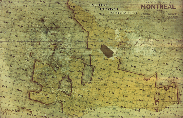
Another historical Map: 1949 Montreal Land Use plan
March 23rd, 2013 by ant6n
This blog wasn’t really meant to become about historical map mashups, but with the city of Montreal (and the Bibliothèque et Archives nationales du Québec) releasing all this interesting imagenary, I made the third map app within as many weeks. This one is a 1949 Land Use plan (source), showing a detailled view of the buildings, many of them named, their uses, street names. This map is not stitched together, and not overlayed with a modern view – it’s the raw scanned pages arranged in a grid. This makes for a primary source, not only showing the data of the map, but also showing the age of the paper it’s on, pencil scribbles, creases and tape fixes. The result looks like this:
Again there’s a full screen version, which can be found here. The 9 principal colors correspond to the following:
- Jaune: résidentiel : unifamilial
- Orange: résidentiel : duplex
- Brun: résidentiel : triplex
- Rouge: commerce
- Rose: industries légères (alimentation, entreposage, vêtements…)
- Violet: industries lourdes (mécanique, chimie, fonderie…)
- Bleu: chemin de fer
- Vert: parcs
- Gris-vert: institutions (administration, écoles, églises…)
Note that some areas are not colored in: Those were not part of the city of Montreal, but independent municipalities. Montreal had quite strange boundaries and a weird shape, reaching the water in the North, but with many cut-outs all around. The city has consolidated much more, but some of those small cities (like Westmount, and TMR) are still holding on to their independence today.
map index
All these map mashups I’ve showcased the last couple of weeks are a work in progress. I hope there will be one master map one day overlaying all the information in one app. This involves the major help of some pixel magicians who’ve been stitching and cleaning images (in particular mare and Luc). I thank them for all their work and hope for the continuation of these projects.
March 27th, 2013 at 17:23
The level of detail on that map is insane! Also, yay, you’re blogging again!
March 1st, 2016 at 12:04
Hi,
I’m moving to Pointe St-Charles in 2 months. Renovating an old house on De la Congrégation right now. I would LOVE to frame this old map of Montréal.
Is there any way I can download those images (in good quality)?
Thanks for your help. And great blog by the way. I’m working for the STM… so I relate!
November 24th, 2017 at 17:52
Salut bien Anton
Très intéressante trouvaille mais il y a des lacunes: entre autre, toute la section concernant le secteur Saint-Léonard (où était tracé l’ancien chemin de la Côte-Saint-Michel, actuel rue Jarry) n’apparaît pas sur cette carte. Pourquoi?
Merci de votre attention
Philippe
December 11th, 2017 at 12:57
Excellent work. I grew up in Montreal West, born in 1951. My family moved from Arvida to Montreal in 1949, and the house they moved to wasn’t built when the drawing was created, but it must have been immediately after. Also, it’s clear that much of NDG wasn’t yet built, but it would be by the time I started commuting to school in NDG in 1959.
Thanks so much for your efforts.
March 27th, 2021 at 10:12
Hi,
Thanks for those great infos.
I would like to print the drawing 56-60 from the 1949 layout, to make a frame.
How can I get a high quality file ? to have the best print possible.
Thanks in advance.
Regards.
Max.
April 5th, 2021 at 11:31
Anyone searching for the source images can find them here: https://www.mcgill.ca/library/find/maps/landuse1949. I can’t find them on the BanQ site unfortunately.