Archive for the ‘Montréal’ Category

Better Buses I: Frequent Service Does Not a Network Make

Tuesday, September 21st, 2010

This is part I of a series on ideas how to make bus services more attractive

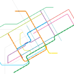
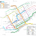
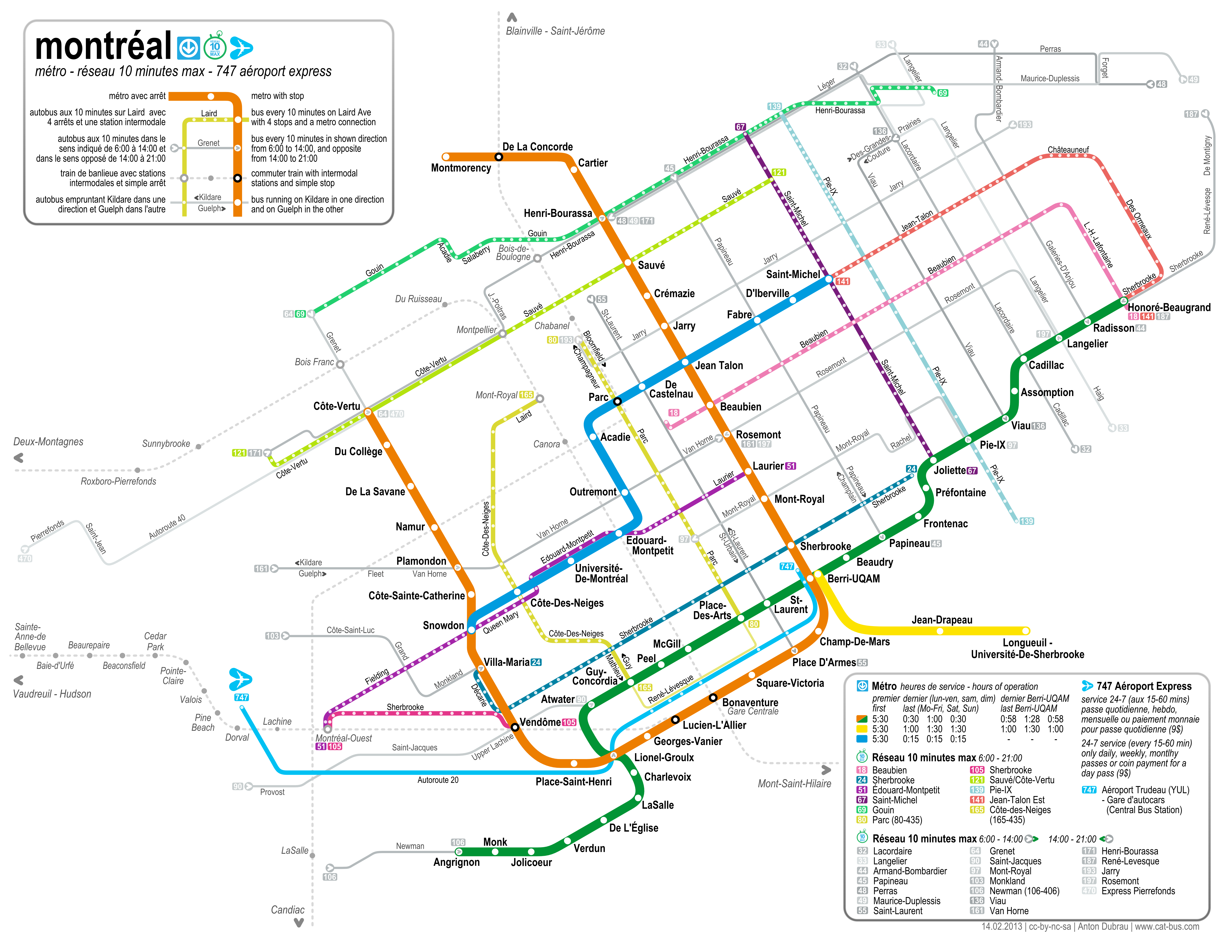
While making a map for Montreal’s frequent bus service, branded the “10 minute network”, it became obvious that just taking a couple of heavily utilized bus lines and upgrading or labeling already existing all-day frequent service doesn’t make a network yet. The STM should now focus on creating creating a new level of service. Before this brand there were two levels of transit within the island of Montreal: A primary, The metro, with high speed, high frequency and good reliability in a network that can be easily understood; and a secondary, a large list of bus lines, with all sorts of different service patterns and some with very low frequency (I am not counting the commuter trains at this point, since they don’t seem to be designed for people on the island of Montreal).

Many users will likely rely on the metro as much as possible and only switch to buses where the metro is not available — or when taking a trip every day. Commuters tend to find the services that is most useful to them, even if it is obscure, infrequent and relies on expert knowledge. The metro on the other hand will get you to many places and the only thing you need to know when you start your journey is the station where you want to get off; no schedules or further geographical knowledge is needed.

The reseau 10 minute max attempts to create a new secondary network, supplementing the metro, which can also be easily understood and which is frequent so that no schedules are needed (we’ll see about the reliability come next winter). It is most useful if it emulates the user experience of the metro as much as possible, while creating a network that makes sense by itself, covering most of the city in tandem with the metro. It should be accessible and appealing to the novice user, who can then reach any part of the city without much preparation etc. This should improve mobility, and thus the ability to rely on public transportation, making it more competitive form of transport.

This idea is partly due to Jarret Walker at provide a similar experience as rail, that they are equal in a way. I believe that rail is the better form of transit in many instances, but it is simply not affordable in most places, either to build or operate. Montreal is currently in phase I and doesn’t even know the costs of the 3 km extension of the blue line. It may be completed by 2016 or so – 10 years after last extension. If the province manages to build only 3km every 10 years, the system will never cover the entire city (because it grows faster than that). Even a planned Bus Rapid Transit line along Boulevard Pie-IX is is now estimated to cost 305$M. Although not grade separated like “real BRT”, it will still cost 20$ million per Km.

Planned BRT along Boulevard Pie-IX - at 20$ M per km

So it is not really realistic to ask for the metro to spread all across the city, or even bus rapid transit as planned on Pie-IX. The secondary network of frequent bus lines is all we have in many parts of the city, and we should make the best of it. In the following series, I will discuss a couple of comparatively simple ways to create a better secondary form of transit, mostly by emulating the user experience of rapid transit. These ideas should not only be applicable to Montréal, but also other cities.

Continue on part II.

A Map for Montréal’s frequent service

Thursday, September 2nd, 2010

As mentioned in a previous post, I’ve been working on a frequent service map of Montreal’s new réseau 10 minute max (10 minute network). Just a couple of days after the new schedule went on effect on August 30th, I am now publishing this map (under cc-by-sa-nc).

The stm also published a map. But theirs is basically just the full system map with the whole system (except the metro) removed and the frequent lines added in thick lines — it’s still a huge map (because it is geographically accurate), for a relatively simple system. Also, the lines often sit on top of the metro lines, so it’s hard to read.

I wanted to make a map that is similarly abstract as the old metro map, to show the similarity between the frequent service network and the metro system itself. Both should be accessible without needing any schedules, or knowing the area well where one is travelling. I wanted to combine the simplicity of the traditional tube map with the look and feel of the Montreal metro map (and the new stm designs) while adding in the frequent bus lines – and all that in a letter format.

The result is indeed letter sized (with 5mm margins), and designed to fold twice (along the legend boxes), albeit with some pretty small fonts. Nevertheless, it should be possible to carry this map along all journeys much more easily than the whole system map — this independence is sort of the intent of the original London tube map, and also of the new frequent service network.

I added the commuter train stations on the island of Montreal, something that the metro map doesn’t show. Although they don’t run frequently, the connections are good to know and an imprtant aspect of the public transportation network — so they are shown in greyed out, dotted lines. I also added the airport express bus, even though it runs at a lower frequency than 10 minutes, because of it’s success and general importance. The legend shows that it runs less often.

The stm chose a system of 11 lines with 10-minute frequent service running form 6am to 9pm, and a set of 19 lines that run frequent in the downtown direction from 6am to 2pm, and in the opposite between 2pm and 9pm. These lines don’t qualify as all-day frequent service, so they are also shown greyed out, with arrows indicating the morning/downtown direction. I assigned colors to the all-day frequent lines as if they were metro lines, based on the sort of pastell color theme of the stm.

A feature that is not even in the full system map is the indication of all stops along the bus lines. While I didn’t actually name any, it still provides useful information – it gives an indication of how long it takes to traverse a certain route (the more stops the longer it takes), and it gives an idea of how many stops it takes to go from one intersection to another. The one should help people to be more independent of schedules by being able go estimate how long a trip will take, and the other helps people to navigate the city riding the bus without knowing a certain area. Both are intended to lower the barrier of entry for new users (or users new to an area, or tourists) to be able to use the bus system. A focus on usability in public transport systems (especially buses) is sometimes lacking, but attempting to create user experience similar to a metro system should help attracting riders.

A 600 dpi version can be found here. And a pdf. Or the svg. (update: I correct errors only on these files.)

This project was partly inspired by Jarret Walkers treatment of frequent service ideas over at human transit. Most of the above links direct to his discussions of the topic. I have also taken a closer look at the bus network.

Check out the most recent update.

Towards a frequent Network Map for Montréal

Tuesday, August 24th, 2010

As posted in Montréalités urbaine and human transit, Montréal now has a frequent network brand. It’s called Réseau 10 Minutes max.

Jarret at Human Transit has been making the case for frequent transit maps for a while now. The idea is that bus service that runs at high frequency should be marked differently from other bus service, because these lines allow us to travel without looking up any schedule. In this way they are similar to rapid transit (like the metro); we only need a map to plan our journey. And some people tend to memorize them so they don’t need any map at all to make basic travel plans through their city.

Montreals Réseau 10 Minutes max includes 11 lines with all day frequent service, and another 20 which have frequent service in one direction until 2pm, and frequent service in the other direction afterwards. This service has to run all day at high frequency, otherwise there is no sense of reliability (i.e. not needing a schedule), and the lines are frequent from 6am to 9pm.

Inspired by Jarrets blog I have been planning to make a frequent network map based on existing schedules. But the STM was quicker than me, and with their new label saved me the work of scraping all their bus schedules and deciding which service could be considered frequent — problematic because the STM generally does not seem to believe in fixed interval schedules, so service that is really frequent during some points during the day might be very infrequent at others.

In a way this service represents a shift of paradigms away from schedules that are exactly modeled by demand, and towards service that is more easily memorized and can be more easily relied upon. The actual improvement in service might actually be fairly small and mostly during times many people don’t travel anyway; but it can create a powerful brand if it is marketed right.

That’s why it is surprising that there has been very sparse information about it so far, although the schedule is to take effect on August 30th. In particular, there is no map yet. Which leaves me to make a map after all. The shown image is the first draft, showing all metro lines and the all day frequent services, as well as the commuter rail (dotted). I opted for a very abstract view, compatible with the existing metro map and the new corporate design of the STM. With all the names and dots missing, in this minimalistic state, I find the map kind of appealing. But more info should really be added to make it actually useful, and I hope to add


  • The 20 one-way-frequent lines (grayed out because they are less reliable)
  • The names of the streets the buses are running on
  • Dots for intersections
  • Possibly little dots denoting every stop — they are a measure of how fast a service is (many stops make a bus slow)
  • A legend

It’s not clear whether it’s better to mark the streets busses are running on by labelling intersecting lines, or simply be putting the name of the street along every line. Also there is the problem of how to mark the direction of frequency. Thoughts are appreciated.

Hidden costs of Parking

Thursday, August 19th, 2010

Free Parking is not as cheap as you might think. At least according to Donald C. Shoup, professor of urban Planning at the University of California, who published a 733-page book on the “The High Cost of Free Parking.” The basic premise is that zoning requirements and regulations requiring large amount of parking act as subsidies to car ownership and car trips.

The subsidies are mostly hidden, which adds to the car owners sense of entitlement to cheap parking availability, and generally to the perceived freedom of the car; but the results are more visible. There is excessive amount of downtown land for cars, causing more sprawl and more automobile usage.

If developers were allowed to face directly the high land costs of providing so much parking, the number of spaces would be a result of a careful economic calculation rather than a matter of satisfying a legal requirement. Parking would be scarcer, and more likely to have a price — or a higher one than it does now — and people would be more careful about when and where they drove.

According to the article, 99% of all car trips in the us end in free parking space and Professor Shoup estimates that in 2002, the subsidy to parking amounted to 127$ billion in the United States. In a way this means that transit users are subsidizing car ownership more than car owners are subsidizing transit, contrary to the general perception.

Within this context it’s interesting that San Francisco started a pilot project which will not only show the availability of all parking spots in certain areas in a smart phone app, but it will also allow the prizes to shift according to market demands. Jarret at HumanTransit views this as the beginning of the free market of parking, but the spots only compute with each other, up to a regulated maximum. In a real market, the land use as parking spots would be in competition other possible uses fore these spaces.

One possible argument for cheap parking is that in places where there are no adequate transportation alternatives, parking is necessary, and without it the city centers will suffer. I believe the argument actually goes the other way round — that an increased focus on automobile travel and ownership, and (possibly indirect) subsidies for parking will hurt public transportation and cause less walkable communities. It will also move residential areas farther away from business owners in downtown, hurting city centers.

Let’s look at Montreal as an example of a city with very high transit use (the second highest in North America, after New York). Presumably there should be enough transit alternatives, so that a lot of parking is not really necessary, and a real market should force them away from the high density downtown areas. That is, parking lots should not be able to compete with actual retail development. I decided to mark a downtown area, and fill out all the parking visible from above. The chosen 1.1 square mile area is enclosed by McGill University in the West, Place des Arts in the North, the old port in the East and the Bell Centre in the South. This area includes the commercial center and the old town, and includes six metro stations and two commuter rail stations. The result is the image above. It is striking how much parking area there actually is smack in downtown. And while Montreal is generally considered a fairly European city, with a lot of transit, a pioneering bike sharing system and many walkable areas, it seems that the urban landscape of downtown is forced into one one huge, ugly parking lot.

On a side note, the inefficient use of space, sprawl and bad downtown development is an example of the negative externalities of car culture, that, just like the problems to health (like obesity or commuting stress), has nothing to do with Pollution and Global Warming. This means that even the electric car, with the first mass produced model coming out later this year (although the introduction is slower than expected), will not solve any of these problems, even if they ran completely on ‘green’ electricity.

Suburban Missed Connection:
Train4Bus – When I arrived, you had just left

Tuesday, August 17th, 2010

One of the problems of transit is topography. How can you provide good transit service where the population density is too low? Ideally one would want good service throughout the network, but of course that’s not affordable. On the other hand these areas still need access to public transportation. So there will always be a fair amount of transit service running at low frequency. But how can you get people to switch from cars to transit (or more importantly, not switch from transit to cars) if you cannot provide frequent service? Most people will not take the bus to save the planet, but they will if it provides similar (or better) mobility as the car.

One way to lose riders to the car is by not providing timed connections. Many services in low density areas are actually feeder lines to more frequent lines, rapid transit lines or commuter trains. If a connection can not be ensured, then the transit agency will lose riders. This seems really obvious, but it’s something that some transit agencies fail to enforce consistently, especially across different agencies.

Case in point: recently a friend of mine bought herself a house and moved into the suburb city of Laval, just north of Montreal. Naturally I asked her how she gets downtown for work (who wouldn’t?), and to my relief I found out she takes the commuter train. She did complain about the bad connection to the bus, which supposedly makes her wait for an hour at the train station all the time — both the train and the bus are infrequent; they come about hourly.

It turns out that the bus often leaves a couple of minutes before the train arrives. This is especially true when going home in the evening. The only short connection during the whole evening is exactly 1 minute, so it’s likely that a passenger will still be stranded for an hour. The bus and the train both come about hourly, and the bus has its terminus there, meaning that the connection is important for that line. The graph shows, for every train arrival, when the next bus will arrive and also when the previous bus left. Ideally the connection should always be like in the morning.

The other way the wait is not quite as long, but it seems the bus is scheduled to arrive half-way between the trains.

To illustrate the issue, it takes the commuter train 30 minutes to get to the suburb station, and the bus another 10 to bring my friend home. If the layover would be 5 minutes, this would mean 45 minutes of travel time (plus some walking). With a 52 minute layover, the travel time is now 92 minutes – more than twice as long. If you assume that the perceived time of waiting is 2.5x the actual time, then going home feels like 170 minutes…

This sort of scheduling problem is not just a fluke, it’s an example of a larger problem in the Montreal area. According to a recent article in the Montreal Gazette, up to 19 transit authorties and regional/municipal bodies are involved in planning. Additionally, Aéroports de Montreal, which runs the Trudeau airport, is pushing it’s own transit agenda to create a non stop rail shuttle to downtown. Currently it looks like their option is going to be chosen, rather than the more integrated plan of the AMT (agence metropolitaine de transport) to create a surface metro in the badly served West Island.

With all these agencies, it is no wonder that there are issues with planning, fare zones, and, well, scheduling. Bad schedules in particular are mostly due to organizational issues, not due to lack of actual transit resources. These issues could be solved with more cooperation, without actually having to increase service. For such infrequent service, schedules make or break the whole transit network. And it is supposed to be a network, not just a set of badly connected infrequently served lines.

I wonder how many more connections are this bad, and whether an individual can do anything to get this fixed. But in the meantime my friend is being pushed into using the car by transit agencies that do not cooperate.