Then and Now Again:1947 Aerial Photography vs Google Satellite
March 13th, 2013 by ant6n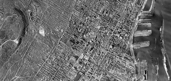
In a sort of continuation of my transit map mashup comparing transit maps from 1941 and 2011, I made another mashup comparing aerial photography from 1947 and now. The city of Montreal published aerial photos from the entire Montreal island, that were made between 1947 and 1949. I was able to get a version of stitched images of the downtown areas and the Plateau (via mare, who used some sort of stitching software). Rotated and Translated to approximately fit google satellite (which actually uses aerial photos as well), and put all together, it looks like this (A full screen version can be found here):
I’ll leave this without much comment, just go ahead and explore. I invite you to comment your observations.
March 13th, 2013 at 14:33
Any intention of completing the map of the island from 1947 with the thounsands of other pictures ?
March 13th, 2013 at 21:36
Beau travail! Fascinant de voir l’ampleur des changements apportés à l’ÃŽle Ste-Hélène et à l’ÃŽle Ronde.
March 13th, 2013 at 21:55
I’m a Montrealer and public transit user. I just came across your blog. It’s amazing!
March 13th, 2013 at 22:28
Well done on this mammoth project. It must of taken quite a bit of your spare time. A sincere thank you!
March 14th, 2013 at 01:47
Noted:
1) on Bishop above Ste-Catherine: you can find the Royal George Apartments, of which only the facade now remains — integrated into Concordia’s McConnell Building. This was just off the corner of Blvd de Maisonneuve, which in 1947 is four separate streets, not yet connected up.
2) Tour Drummond, on Drummond. As they built the Metro’s Green Line, they also knocked through Blvd de Maisonneuve, two lanes of which ran through the first two storeys of Tour Drummond, until in was demolished in the 90ies, maybe?
3) At the corner of Kitchener and de Maisonneuve in Westmount: a farm! Cultivated fields, about a block from Westmount City Hall. Now a huge apartment complex.
Nice work!
March 14th, 2013 at 02:00
@Glenn,Leo
Nice observations!
@Propos, Nick
Intention, yes. But it may be complicated, and take time. Already the stitching together is causing drifts in the imagery that make everything hard to line up. I posted some details on how I built this on reddit.
March 14th, 2013 at 13:09
Ce que vous avez fait avec nos photos d’archives de 1947 est très intéressant.
Bravo!
Mario Robert
Archiviste en chef
Ville de Montréal
March 14th, 2013 at 13:09
You might be interested in this web-based art / writing project – contains maps as satellite photos of Montreal inc Google Maps from different erras. “in absentia” http://luckysoap.com/inabsentia
March 14th, 2013 at 13:24
Amazing stuff!!
I’ve been looking at the individual archive images, having them stitched together makes it much easier to find things, like specific intersections.
It always amazes me how much has changed and how much green space there was on the island 65 years ago.
It would be nice to have an overlay with an adjustable transparency so the changes are easier to see. I’ll manage with what’s available.
Thanks for the hard work
March 14th, 2013 at 13:47
This is great! Thanks for putting in the time to stick everything together – would love to see the whole island stiched together. good work!
March 14th, 2013 at 15:19
Great work – thanks!!
March 15th, 2013 at 13:18
Nice job, but there are major stitching problems with Mount Royal. For example, look at the portion where the road goes up the mountain. In the 1947 aerial image, you can clearly see the tunnel, in the stitched version, it is severely distorted.
March 15th, 2013 at 14:29
Bravo ! Very well done. Seeing the rest of the island would be phenomenal.
March 15th, 2013 at 23:13
I’m very confused by the McTavish reservoir in the 1947 shot. I know the reservoir has been there since the late 1800s but Wikipedia tells me that it wasn’t covered until the 50s – so what are we looking at in the picture? Just an *empty* reservoir? Maybe, but I doubt it…
Anyhow – good work with this. Fascinating!
March 15th, 2013 at 23:43
@Michel
I was wondering about the same thing! My theory is that the wikipedia article is wrong, and that the reservoir was covered exactly 10 years earlier, and the aerials show their construction. On the other hand, they might’ve just emptied it to clean it or something.
March 27th, 2013 at 17:31
Among other things, I’ve learned that the parking lot behind my building has been there for over 65 years!
April 16th, 2013 at 08:26
Thank you so much for creating and posting this amazing site. I spent a good portion of my morning going back in time to tour the streets of late-forties Griffintown and Little Burgundy. Sitting proudly on Canning Street (just north of Notre Dame) was Royal Arthur School, where I began my teaching career in 1973. The school was torn down in 1982.
I have always been fascinated by the history of the two communities; its families, stores and churches. Your map adds so much to my understanding. Thank you.
April 16th, 2013 at 16:26
Thank you very much….
You’ve done an amazing job….
I owe you a beer….
May 9th, 2013 at 01:27
Very nice! Thanks for posting!
July 31st, 2013 at 16:36
re: covering the McTavish reservoir
Check this page from McGill’s site; http://www.arch.mcgill.ca/prof/bourke/arch672/fall2002/reserv.htm
October 4th, 2013 at 20:05
Fantastique. Je viens de découvrir ces cartes interactives et je viens de m’apercevoir que j’ai oublié d’aller souper. Quel voyage dans le temps.
November 21st, 2014 at 16:01
Incredible footage and photos. Cant wait until we can do something similar with drones , check our portfolio http://www.aerialquebec.com for future projects
March 21st, 2016 at 22:26
C’est vraiment incroyable de pouvoir superposer des images de 1947 sur la cartographie Google. Grâce à ces images, j’ai pu confirmer que je n’habite pas sur un ancien site d’enfouissement, contrairement à la cartographie rendue publique par Radio-Canada. Selon l’émission “La Facture” à Radio-Canada, plusieurs résidences ont été construites sur des anciens sites d’enfouissement et cette information a été cachée par les autorités municipales. Plusieurs se trouvent sur le Plateau et dans Rosemont.
April 7th, 2016 at 16:26
The google satellite photos at the closest zoom levels are stunning. I can’t figure out how to get google maps/earth to display these beautiful areal shots. How did you find them?
February 24th, 2018 at 16:05
I have just discovered your wonderful 1947 aerial photo montage of Montreal’s downtown area. Last summer I executed a similar personal project, using 20 photos of Montreal’s Rosemont neighbourhood in 1947.
The result is posted at
https://sites.google.com/view/flyback1947/home
(my first and only experience in creating a web page). It required many hours of effort using the open-source MapKnitter web tool kit. (See https://mapknitter.org/maps/rosemont-1947 .)
I would like to hear from anyone who might know of a less arduous (and affordable) method or tool.
An interesting challenge would be to combine more of these images without sacrificing the original remarkable resolution. I’d like to be able to navigate the landscape seamlessly with plenty of zooming capability.
Thanks!
February 24th, 2018 at 20:47
@Andrew
Very nice. I was working on some technology to continue this project and cover the whole island, but it turned out to be too time intensive to do just for fun…
November 21st, 2021 at 01:30
Still almost 10 years later, that map is awesome!
Please contact me if you ever need funding to maintain that website available.
February 8th, 2022 at 19:56
Interesting. Part of the Old Chinatown was Streetcar yards which is now the Montreal Convention Centre! Wonderful map!