REM – A Look At The Ridership Study Summary
August 31st, 2016 by ant6nRidership Study Reveals Suburban, Car-Centric, Peak-Centric Focus; Airport Ridership is Abysmal; brings into Question again the Cost-benefit of the West Island and Airport Branches; ignores urban network effects.
Things are starting to roll for the REM, the BAPE (environmental impact) hearings started this week, there are more presentations and people have started asking questions. The process is moving super fast, and it can feel difficult to keep up. The process is strange, with people asking questions from the high level-political, financial and high-level technical on the one hand, to people asking about some specific impact near their house, all jumbled together in one giant process for a giant project worth billions.
One very interesting question asked at the BAPE was the first one, by journalist Michel Morin, who asked what the Caisse expects as a return for this project, 6%, 9%? The Caisse people didn’t answer the question. He then went on to say that if the return is that high, then why shouldn’t the government just borrow money, at 3%, and pay for the damn project itself!
We’ve also gotten confirmation that the REM is refusing to share track with VIA rail.
Meanwhile we’re getting drowned in paperwork, studies over studies that makes it hard to identify issues.
One document published yesterday is the ridership study for the REM, or better, a summary thereof. The most interesting tables are the the daily ridership per branch…

…and the table showing ridership in the morning peak per station:
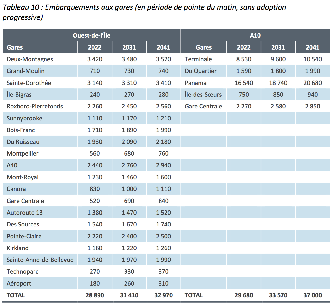
Here are some observations:
1. The First-Year Ridership and 20th-year Ridership are very similar
Most new transit lines take years to grow their ridership to their target level. Apparently the REM will have most of its ridership in the first year of operation already. I’m not sure what the reason for this is; is it due the used model or will this actually happen like this? This is a concern since the capacity of the line is chosen a bit low, being a light metro. Will the capacity be sufficient twenty years after opening?
Update: It has been pointed out to me that the per-station ridership is shown without ‘adoption progressive’, i.e. without assuming high ridership growth. If you look at the per-branch table (above), which does show ‘adoption progressive’, you can see a 30% ridership gain over twenty years. The question whether we will have enough capacity in the future does remain.
2. Nothing New in the North And South
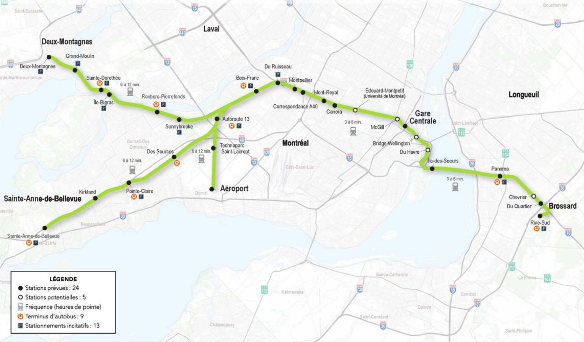
The ridership study considers the four branches of the REM: the existing Deux-Montagnes line, the West Island (St-Anne-de-Bellevue) branch, the airport spur and the Champlain bridge corridor serving Brossard, also known as the A10 corridor.
Out of these, the A10-corridor and the Deux-Montagnes line bring in the most ridership, the numbers are in line with what we’ve seen before. There are few surprises.
One thing I did find interesting is that the South Shore branch has a relatively large percentage of ridership coming from the terminus of the line. In my mind this was basically just a giant parking lot and bus terminus at the edge of the developed area of Montreal, surely it shouldn’t bring in much ridership. But it brings in about half the ridership of Panama, the major station on the A-10 corridor. I expected to see three quarters of the ridership at Panama.
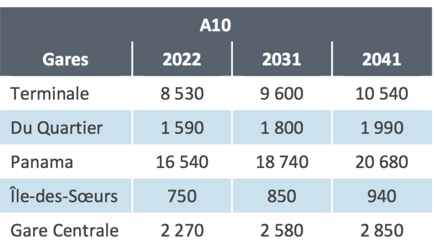
The terminus station will also see some of the largest growth of any station. That’s a concern; ridership growing at the end of the line probably means sprawl in action.
3. The Mascouche Line is Assumed to stay Crippled
The Mascouche line is apparently assumed to stay abysmal, if we go by the ridership numbers by station. Only 2,440 riders during the morning peak means that there will be at most 4,880 trips per day that are transfers from the Mascouche line. Given that 95% of the Mascouche line riders goes downtown, and that the Orange line connection is assumed to be much less convenient in the study, this would actually mean a reduction of the ridership on that line, which was 6,400 per day in 2015 (see page 9 of the AMT annual report).
The Mascouche line was supposed to reach 11,000 users eventually, on the line as it exists today. I’m not sure whether the study just ignores future growth, or whether the forced transfer the REM will create will reduce ridership.
If we build the REM relying on these ridership numbers, we cannot add stations and increase service on the Mascouche line which passes by hundreds of thousands of transit-underserved people in Montreal-North and Montreal-Est. An upgraded Mascouche line, besides having the forced transfer rather than direct connection downtown that we have today, would have the problem that the REM simply won’t have enough capacity to get people downtown.
4. The study Ignores All other Transfers
Besides the Mascouche line, the ridership study clearly ignores most network effects within Montreal. The study ignores transferees from the St-Jerome line, and doesn’t include the Edouard-Montpetit station, so ignores transferees from the Blue line as well. The Blue line has more riders per day than is projected for the whole REM network (about 250K vs 150K), and many would probably transfer to the REM if given the chance to get more quickly downtown. So Blue line transfers could overload the under-designed light-metro.
If we design now a regional network with line-capacities built around the conclusions of this study, we may end up having severe capacity issues, an issue I’ve raised back in May.
5. The West Island Branch is Suburban, Car-Centric, Peaky & Low-Ridersip
The ridership on the West Island Branch is actually more than originally shown – instead of 11,000 trips per day, the branch will generate 16,800 trips. Instead of a third of the ridership of the most busy bus lines in Montreal, it will receive half their ridership.
What’s interesting is how this ridership compares to the parking along the stations of that Branch (Autorute 13, des Sources – St-Anne-de-Bellevue):
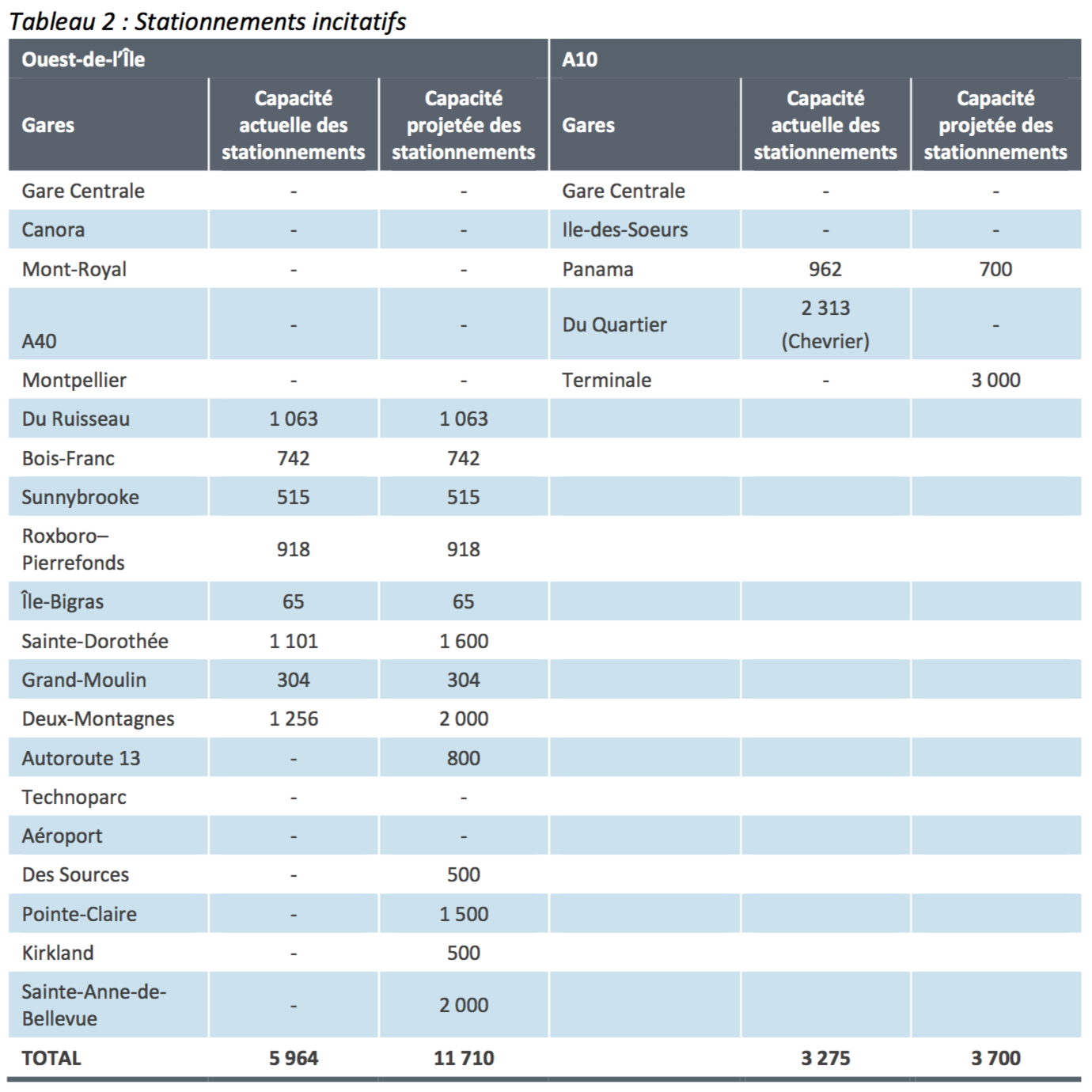
The five stations will have a combined capacity of 5,300 parking spaces. Since every parking space can generate two transit trips, this means 10,600 trips per day may come from car drivers, assuming full parking utilization and one single occupant per car.
This means that depending parking utilization and how many people travel together in a car, 63% of the ridership will come via car.
The REM people have promised that they will design the stations for bus connections first. But in reality, this whole branch is designed for cars.
Also, if we compare the daily ridership on that line with the peak morning ridership, we get that the 5 stations on the West Island branch have 8,240 trips during the morning peak — that’s almost exactly half of the presumed daily ridership (which would be 8,400 trips).
This means outside of rush hour, the trains will be empty. But the system is built to run frequently all day long.
If ridership on the St-Anne-de-Bellevue branch mostly comes by car, mostly during the Peak time, then what is the point of building this all-day high-frequency light metro? This driving, peak-only clientele can be perfectly adequately served via the existing Vaudreuil-Hudson line, assuming some improved service, which also has the virtue of continuing to towns a bit further out and actually connects more centrally to communities.
There may still be a case for a transit line in the North of the West Island, but maybe only as far West as Fairview. The line should also be closer to actual population, and built with better & more direct connections to buses.
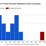
6. The Airport has Abysmal Ridership
The airport branch appears more and more abysmal. I’ve written about how airport connectors suck, worrying that the 10,000 ridership numbers for the airport spur seem optimistic. Now it seems the line won’t have more than 3,000 or 4,000 riders – slightly less than the 747 bus line.
The recent decision by the REM people to build an expensive 4km deep-bore tunnel, to avoid impacting the wetlands North of the airport, means the cost-benefit of this branch is more and more in question. A short spur from the Vaudreuil-Hudson line would be much cheaper, and a much more reasonable investment given the low potential ridership.
Conclusion
The ridership study reinforces the conclusion I had when trying to analyse the cost/benefit of the REM: The project will mix good transit lines with bad ones, and the public doesn’t get to pick what actually gets built.
The Deux-Montagnes line and A-10 corridor have good ridership and some sort of rapid transit is justified; the West Island spur is very questionable. The airport spur looks like only a political decision.
The West Island corridor is suburban and car-centric, the claim that this line is designed for bus feeders first is specious at best.